Last Saturday’s earthquake was the second strongest in the last 50 years.
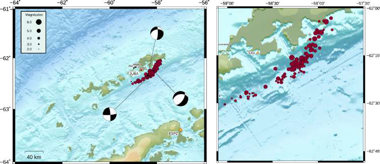
What is happening in Antarctica? That is the question many are asking after the violent earthquake, magnitude 7.0, that occurred this weekend. The telluric movement last Saturday that forced the evacuation of the Chilean Antarctic bases in King George Island is not isolated, but part of a process that began years ago.
Geophysicist of Universidad de Magallanes, Rodrigo Adaros, explained that last year a station located near Argentinian base Carlina registered a seismic swarm with over 30.000 telluric movements, which was confirmed by other two close Antarctic stations.
The explanation for that is the creation of a submarine trench in the Bransfield strait, more than 140 kilometres long and that separates the Shetland Islands, among them King George Island where the Chilean Antarctic bases are located, from the Antarctic Peninsula.
Adaros pointed out that base Carlina and another Italian station have satellite GPS and geodesic positioners that can determine if a point is moved with millimetric precision. When the seismic swarm occurred, that equipment showed equally concerning records. He said that during these three months, there was a significant increase of almost 15 millimetres per year, which is what separated South Shetland Islands from the Antarctic Peninsula. Therefore, several investigations start to come together and conclude the same. There was an increase of the seismicity and, in parallel, there was an unusual movement in the separation between the Shetland Islands and the Antarctic Peninsula.
Further studies. Doctor Sergio Barrientos, director of the National Seismological Centre, added that the current records were consistent with the existence of a trench, a crust which is opening and material that is coming out from the mantle.
Moreover, he indicated that the GPS measurements show that, since August, the separation rate changed drastically from 8 millimetres per year to 15 to 20 centimetres per year, which shows that something happened and explains the seismic activity.
Even though they are highly elevated, Barrientos explains that those numbers are still not alarming by themselves. Consequently, next 5 February, researchers from the Universidad de Chile will start an expedition in the Antarctic in order to study and monitor this unusual seismic activity.
Doctor Marcelo Leppe Cartes, director of INACh [Chilean Antarctic Institute] stated that the installation of state-of-the-art sensors for the measurements of these telluric phenomena has been planned with Onemi [Chilean National Office of Emergency of the Interior Ministry], the Hydrographic and Oceanographic Service of the Chilean Navy (SHOA) and, particularly, with the Seismic Risks Programme from the Universidad de Chile.
Source: El Pingüino Newspaper. Date: Thursday, 28 January 2021